About ActiMap - Outdoor maps & GPS
ActiMap is a powerful GPS navigation app built for hikers, cyclists, ski tourers, and outdoor explorers who need reliable offline maps and tracking — without ads or subscriptions, and with no registration. Just maps and...
ActiMap is a powerful GPS navigation app built for hikers, cyclists, ski tourers, and outdoor explorers who need reliable offline maps and tracking — without ads or subscriptions, and with no registration. Just maps and navigation.
🧭 BUILT FOR REAL NAVIGATION
ActiMap focuses on what matters most outdoors: accurate positioning, clear maps, and reliable tracking.
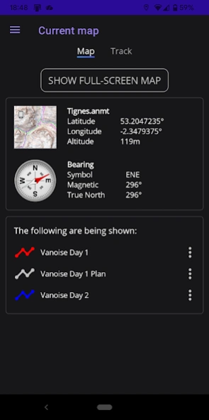
~ GPS location, heading, and compass (true & magnetic north)
~ Record tracks and view real-time altitude profiles
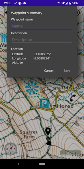
~ Add waypoints and points of interest
~ Follow GPX routes and tracks
🌍 WORLD & NATIONAL MAP COVERAGE
Use a wide range of topographic and outdoor maps from many countries including the UK, USA, France, Germany, Norway, New Zealand, and many more, including:
~ OpenTopoMap (topographic maps with contours)
~ CyclOSM (cycling maps)
~ Satellite imagery
~ UK Ordnance Survey premium leisure maps
~ Other National mapping sources (e.g. USGS, IGN, LINZ)
Add your own map sources or import from the ActiMap library.
📥OFFLINE MAPS
Download or cache maps for use without a signal - ideal for hiking, biking, and remote areas.
~ Download regions for offline use
~ Pause and resume downloads
~ Cache maps for offline use with less storage needed
🔄 IMPORT & EXPORT
Work with standard GPS formats:
~ Import and export GPX tracks and routes
~ Import TCX files
~ Share maps, routes, and tracks with other apps
⚙️ DEVICE FEATURES
Designed for outdoor use:
~ Clean, easy-to-use interface
~ Light and dark modes
~ Smooth zoom and map scrolling
~ Background location tracking
~ Low battery usage
~ Multi-language support
🚫 NO CLUTTER, NO SOCIAL FEATURES
ActiMap is focused purely on navigation.
No registration. No social feeds. No activity sharing. No fitness tracking. No distractions. Just reliable GPS navigation and maps for the true explorer.
🌍 WORLD & NATIONAL MAP COVERAGE
Includes map sources for many countries including the UK, USA, France, Germany, Norway, and more. The map library continues to grow.
⬆️ STANDARD EDITION UPGRADE
The free edition gives you everything you need for casual use and to experience ActiMap, including offline maps. Edition upgrades are available via in App Purchase. The standard edition gives you:
~ Unlimited tracks and offline maps
~ Faster and larger map downloads
~ The ability to export and backup your maps and tracks
~ Access to map sources requiring an API key, such as OpenCycleMap
ℹ️ NOTES
ActiMap provides access to publicly available map sources. Map data licensing and usage rights remain with their respective providers.
Previous Versions
Here you can find the changelog of ActiMap - Outdoor maps & GPS since it was posted on our website on 2019-08-13 12:00:13.
The latest version is 2.2.10 and it was updated on 2026-10-12 19:13:51. See below the changes in each version.
ActiMap - Outdoor maps & GPS version 2.2.10
Updated At: 2026-10-06
Changes: 2.2.10
~ Fixed an issue whereby the compass could become misaligned after the device was held inverted until restored to normal portrait orientation
ActiMap - Outdoor maps & GPS version 2.2.9
Updated At: 2026-10-01
Changes: 2.2.9
~ Fixed an issue whereby the app could crash if the home page 'Current Map' option were selected too quickly after launch
~ Fixed an issue whereby page navigation could briefly be incorrect after completing a map download
~ Improved visual fade-in of the full-screen map
~ The main hamburger menu is now available from the map library import picker page, since the back button was superfluous
ActiMap - Outdoor maps & GPS version 2.2.7
Updated At: 2026-09-22
Changes: 2.2.7
~ Grid references are now shown to 10m precision in ActiMap Standard; they remain at 100m precision in ActMap Free
~ Added a version check when trying to view an offline map to ensure the format is supported, prompting to update if not
~ Added support for iOS
ActiMap - Outdoor maps & GPS version 2.2.6
Updated At: 2026-09-15
Changes: 2.2.6
~ Added support for downloading maps with a custom (non-web-mercator) projection
~ Fixed a recently introduced issue whereby the app could crash on the current map page if no current map were selected
~ Fixed an issue whereby the Free edition would report the incorrect maximum number of allowed offline maps when exceeded
ActiMap - Outdoor maps & GPS version 2.2.4
Updated At: 2026-09-08
Changes: 2.2.4
~ The on-map current location indicator now correctly orientates according to True North rather than Magnetic North for greater accuracy
~ Increased the size of the vertical ellipses context menu image buttons slightly on all lists for ease of use
~ Fixed an issue whereby the app could crash if a GPX track or route were shown and located on the map if the full map page had not been visited already
ActiMap - Outdoor maps & GPS version 2.2.3
Updated At: 2026-08-28
Changes: 2.2.3
~ Added an option to point the current location indicator in the direction you are facing (heading) instead of the direction of travel (course)
~ Improved the display of some imported tracks, such as those generated by the OS App, by hiding non-informative waypoints
~ Added some missing multi-lingual translations to text on the full-screen map page
~ Fixed an issue whereby an imported GPX file with empty rte, trk, or trkseg, elements could fail to display properly
ActiMap - Outdoor maps & GPS version 2.2.1
Updated At: 2026-08-24
Changes: 2.2.1
~ Fixed an issue whereby a cached online map thumbnail could fail to display if there was no internet connection
~ Fixed an issue whereby a full-screen online map display could become slow to respond if there was no internet connection
~ Now displays a custom tile image for an online map if it has not yet been cached and there is no internet connection
ActiMap - Outdoor maps & GPS version 2.1.3
Updated At: 2026-07-23
Changes: 2.1.3
~ Fixed an issue whereby the Back button on the map screen could be shown even when the option to hide it was selected
~ Fixed an issue whereby the compass needle or dial alignment could be incorrect immediately after changing compass styles
~ Fixed an issue whereby changing language could occasionally fail to immediately translate all item text
ActiMap - Outdoor maps & GPS version 2.1.2
Updated At: 2026-07-21
Changes: 2.1.2
~ Added different current location indicator options in Settings to improve on-map visibility
~ Fixed an issue whereby the preferred GPX track width was not saved when changed in Settings
ActiMap - Outdoor maps & GPS version 2.1.0
Updated At: 2026-06-29
Changes: 2.1.0
~ New pricing: Now comes as a Free Edition with an in-app upgrade to the Standard Edition
~ Improved the layout performance of the tracks list with large numbers of tracks
~ Fixed an issue whereby pull-to-refresh was sometimes available other than on the online maps list
~ Fixed a regression issue whereby the map thumbnail was sometimes not displayed on the current map page
Disclaimer
Official Google Play Link
We do not host ActiMap - Outdoor maps & GPS on our servers. We did not scan it for viruses, adware, spyware or other type of malware. This app is hosted by Google and passed their terms and conditions to be listed there. We recommend caution when installing it.
The Google Play link for ActiMap - Outdoor maps & GPS is provided to you by apps112.com without any warranties, representations or guarantees of any kind, so access it at your own risk.
If you have questions regarding this particular app contact the publisher directly. For questions about the functionalities of apps112.com contact us.